Monday, June 2, 2014
The people of Iceland are super friendly and super helpful. Everyone has excellent English.
Our room was peaceful, and breakfast was not crowded, unlike at the hotel in Reykjavik.
We got an early start this morning, because we had a lot we wanted to see. We started with the Seljalandsfoss, a 40 meter high waterfall. It is unique in Iceland because you can walk behind the cascade via a footpath at the base of the cliff. We really enjoyed it.
The next stop was Skogáfoss. It is a magnificent 60 meter tall waterfall at the foot of the Eyjafjoll mountain range. Legend has it that the first Viking settler in the area hid a treasure in the cave behind the cascade. We didn't stay here long because it was raining and we were getting soaked. Not keen on getting jeans all wet through (again) when we only packed two pairs...... Too late.

We had about 45 minutes, so we went to the Skogár Folk Museum. Inside the main building they have lots of antiques and artifacts (a wall full of old cell phones, for instance). It felt like walking through an antique shop in St Jacobs.

Far more interesting were the original turf farms that show how people lived hundreds of years ago. We could actually walk through them. These were buildings that used rocks for walls and grass for roofs. The stairs going into the loft were 2 feet wide and the steps were only 6 inches deep. Only skinny people could live there.

There was also a Transportation Museum with lots of old cars and trucks.

Far more interesting were the original turf farms that show how people lived hundreds of years ago. We could actually walk through them. These were buildings that used rocks for walls and grass for roofs. The stairs going into the loft were 2 feet wide and the steps were only 6 inches deep. Only skinny people could live there.
There was also a Transportation Museum with lots of old cars and trucks.
We drove past Eyjafjallajökull (pronounced [ˈeːɪjaˌfjatl̥aˌjœːkʏtl̥] ha ha ha). It is actually a combination of 3 Icelandic words meaning Island Mountain Glacier. It is famous for shutting down air travel in 2010 when the volcano under the glacier erupted. It threw volcanic ash several kilometres up in the atmosphere which led to air travel disruptionfor six days. As of August 2010, Eyjafjallajökull was considered dormant. We were told that whenever Eyjafjallajökull erupts, nearby Ketla follows within 2-3 years. But it has now been 4 years.......
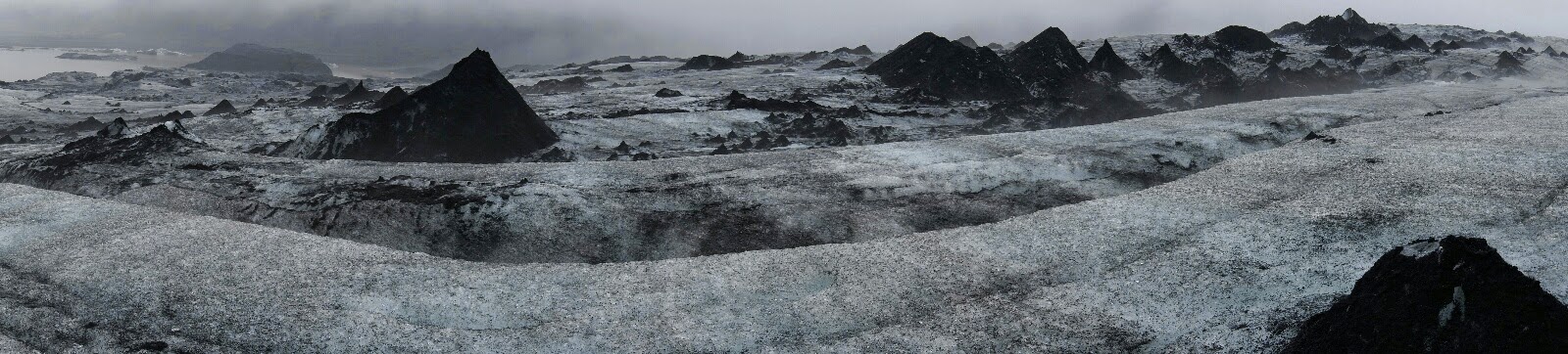
After taking the wrong road because we were given the wrong GPS co-ordinates, we made it just in time for our booked excursion. We took a glacier walk on Sólheimajökull Glacier (a part of the Mýrdalsjökull Glacier) on the south coast of Iceland. It is 600 km2 and 200 m deep on the part we walked. First, there was a lesson in ice walking and they equipped us with harnesses, helmets, crampons, and ice axes. We had to take a 15 minute hike to get to the glacier, it used to reach right down to their base. Then we headed onto the glacier. Walking in crampons was interesting - you had to stamp your feet when you walked, and it felt like your ankles wanted to twist. But we got used to them. There was some amazing terrain with crevasse, sink holes, and ice ridges. We wondered why we had to wear the harnesses. It seems it was just so our guide could grab it at the back so we could lean over and stare into the crevasses. The ice had a layer of silt on it, so it wasn't pristine. There was only us and one other couple from Czech Republic, so our guide Daniel took us down to an ice cave. At least it was an ice cave a week ago, it has changed. He told us that somewhere on this glacier they found a WWII plane, that is still there. The hike was about 2 hours long, and we enjoyed it tremendously, but GOSH it was a workout!


From a glacier to an ocean in 10 minutes. Reynisdrangar are basalt sea stacks situated under the mountain Reynisfjall near the village of Vik. The columns rise right out of the ocean. Legend says the stacks are a result of two trolls dragging a three-masted ship to land unsuccessfully. When daylight broke, they became needles of rock.

Vik is Iceland's most southerly village, and is famous for its black beach that has been used in films and music videos. This was rated one of the world's top 10 beaches.

Anton was tired so Frankie had to drive, and of course no sooner had she taken the wheel than we had to go through our first construction zone. We drove through amazing landscapes that looked like piles of moon rocks. A sign said it was fields of wooly fringed moss.

Anton was tired so Frankie had to drive, and of course no sooner had she taken the wheel than we had to go through our first construction zone. We drove through amazing landscapes that looked like piles of moon rocks. A sign said it was fields of wooly fringed moss.
We wanted to find Fjaðrárgljúfur but it wasn't posted from the road, so we drove into Kirkjubaejarklaustur (a village with 120 people) and found a helpful info center. Often what you get for "info" is just a sign at the side of the road. For such a small town, you would think they could shorten the name.
While we were in Kirkjubaejarklaustur, we took a small walk to find Kirkjugólfið which means “church floor”. There are basalt columns in the earth, but only the tops can be seen, and this gives it the appearance of a paved church floor.

Now that we knew where Fjaðrárgljúfur was, we found the road and found out it is an F road, meant for 4 wheel drives only. We were pretty excited: our first off-roading in Iceland! For 5 whole kilometers! Fjaðrárgljúfur is a canyon in south east Iceland which is up to 100 m deep and about 2 kilometres long, with the Fjaðrá river flowing through it. The rock formations have interesting shapes. One is shaped like a finger, so it is said that a troll is buried there. This is the canyon from above.
While we were in Kirkjubaejarklaustur, we took a small walk to find Kirkjugólfið which means “church floor”. There are basalt columns in the earth, but only the tops can be seen, and this gives it the appearance of a paved church floor.
Now that we knew where Fjaðrárgljúfur was, we found the road and found out it is an F road, meant for 4 wheel drives only. We were pretty excited: our first off-roading in Iceland! For 5 whole kilometers! Fjaðrárgljúfur is a canyon in south east Iceland which is up to 100 m deep and about 2 kilometres long, with the Fjaðrá river flowing through it. The rock formations have interesting shapes. One is shaped like a finger, so it is said that a troll is buried there. This is the canyon from above.


On our way out of the F road, we saw a farm hotel which also said restaurant, so we stopped to see if we could eat our one restaurant meal of the day. Out of the 4 meal choices they offered, 3 were labelled gluten-free! Great!
After a really nice dinner, we drove to find Dverghamrar, which is a small canyon full of hexagonal basalt columns. It is a protected national monument, and dwarves live here according to legend. We think we heard one. Okay, it was only a bird, but it made REALLY strange noises!

Tonight is a rustic, simple, functional hotel, but a great view. We seem to be in a valley between some small mountains.

After a really nice dinner, we drove to find Dverghamrar, which is a small canyon full of hexagonal basalt columns. It is a protected national monument, and dwarves live here according to legend. We think we heard one. Okay, it was only a bird, but it made REALLY strange noises!
Tonight is a rustic, simple, functional hotel, but a great view. We seem to be in a valley between some small mountains.
No comments:
Post a Comment