Saturday, February 16, 2019

Bellavista Cloud Forest Reserve


Thursday, February 14 - Saturday, February 16, 2019

Yes, we are still alive!  For the last 3 days we have been at an eco-lodge in the Andes Mountains, with NO internet whatsoever.  So this will be a 3 in 1 blog for the last few days.


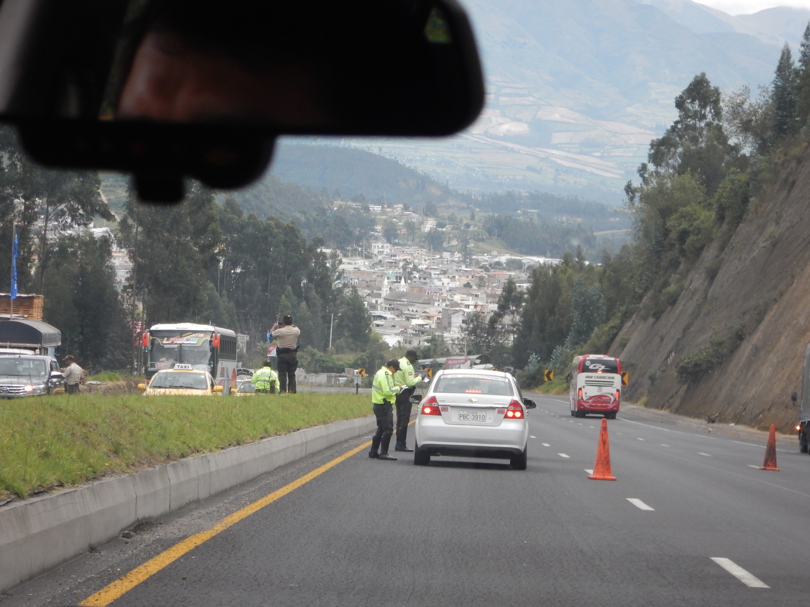
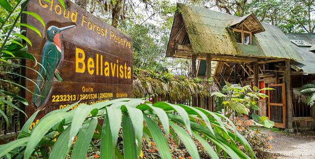
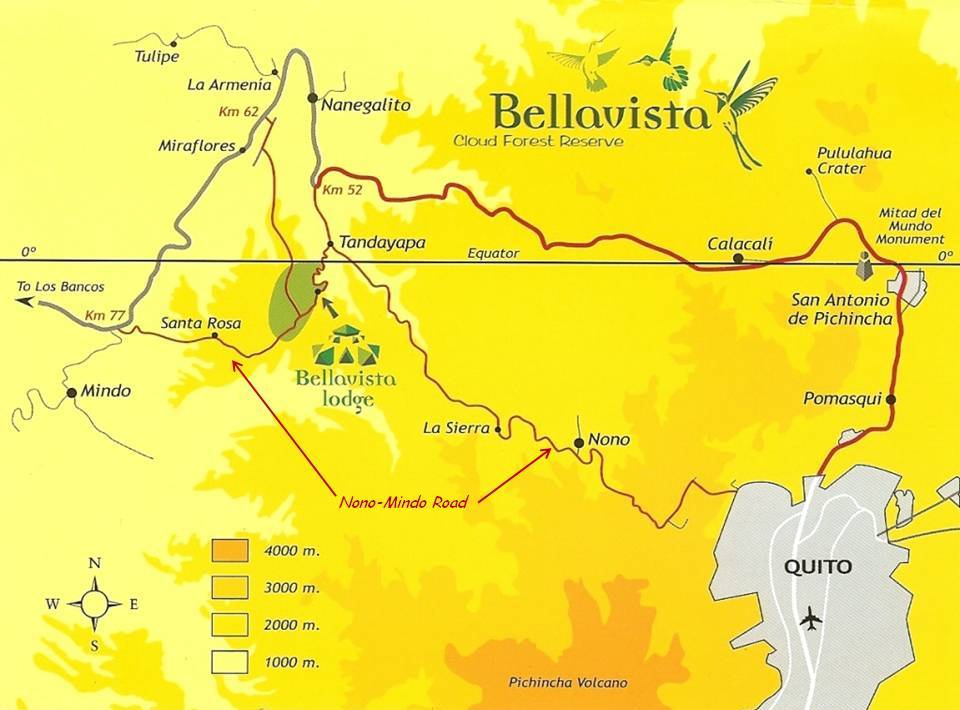
We were picked up at 6:30 am on Thursday for a 3 day stay at Bellavista Cloud Forest Reserve. It was a 2 hour drive west of Quito (50 km).


Image result for bellavista cloud forest bird variety
imagecredit:https://galapagos2009.wordpress.com/day-by-day-activities/quito-adventures/bellavista-cloud-forest-reserve/

Bellavista Cloud Forest Reserve is a 2000 acre private conservation area located on a high ridgeline above the Tandayapa Valley, on the western slope of the Andes Mountains. It ranges from 5000 – 8000 feet (1550 – 2500 m) high in elevation.


Image result for bellavista cloud forest reserve
imagecredit:https://www.jasmineholidays.co.uk/hotels/bellavista-cloud-forest-reserve

Bellavista was established in 1991 (from a formerly deforested area) by Richard and Gloria, who both have extensive experience in ecotourism. Richard was a Galapagos naturalist guide, and Gloria helped write the first Columbian tourism guidebook to Ecuador. From the owners:

Conservation is forever, and that is our goal. The project (for that is what Bellavista is!) is central to our lives and a source of deep satisfaction.

Our stay here included all meals, lodging, and hiking with a naturalist guide.


Our room was called the Alemana Suite.  It was rustic.


Bellavista has 20 trails ranging in difficulty, and offers 3 guided hikes a day (6:30 am, 9:30 am, and 3:00 pm). Guides take a maximum of 8 hikers. You are also welcome to hike on your own with a provided map.


There are over 330 species of birds here. In fact, in the Audobon Bird Counts, this area has listed the highest number of species seen in one day, since 2006.  There were some VERY serious bird watchers here at this eco-lodge, but we really didn't have a clue.
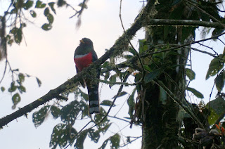


The cloud forest birds are most active right after a rain, when the insects are most prolific.

Bellavista has a nice area to watch the hummingbirds. They get between 8-14 species of hummingbirds at their feeders everyday.


We were even able to get the hummingbirds to land on our fingers!


One of the iconic features of the cloud forests are the epiphytes, which can be seen everywhere growing on the different trees. An epiphyte is a non-parasitic plant that grows on another plant. This would include ferns, bromeliads, air plants, and orchids. In fact, one out of every 4 plants here is an orchid.
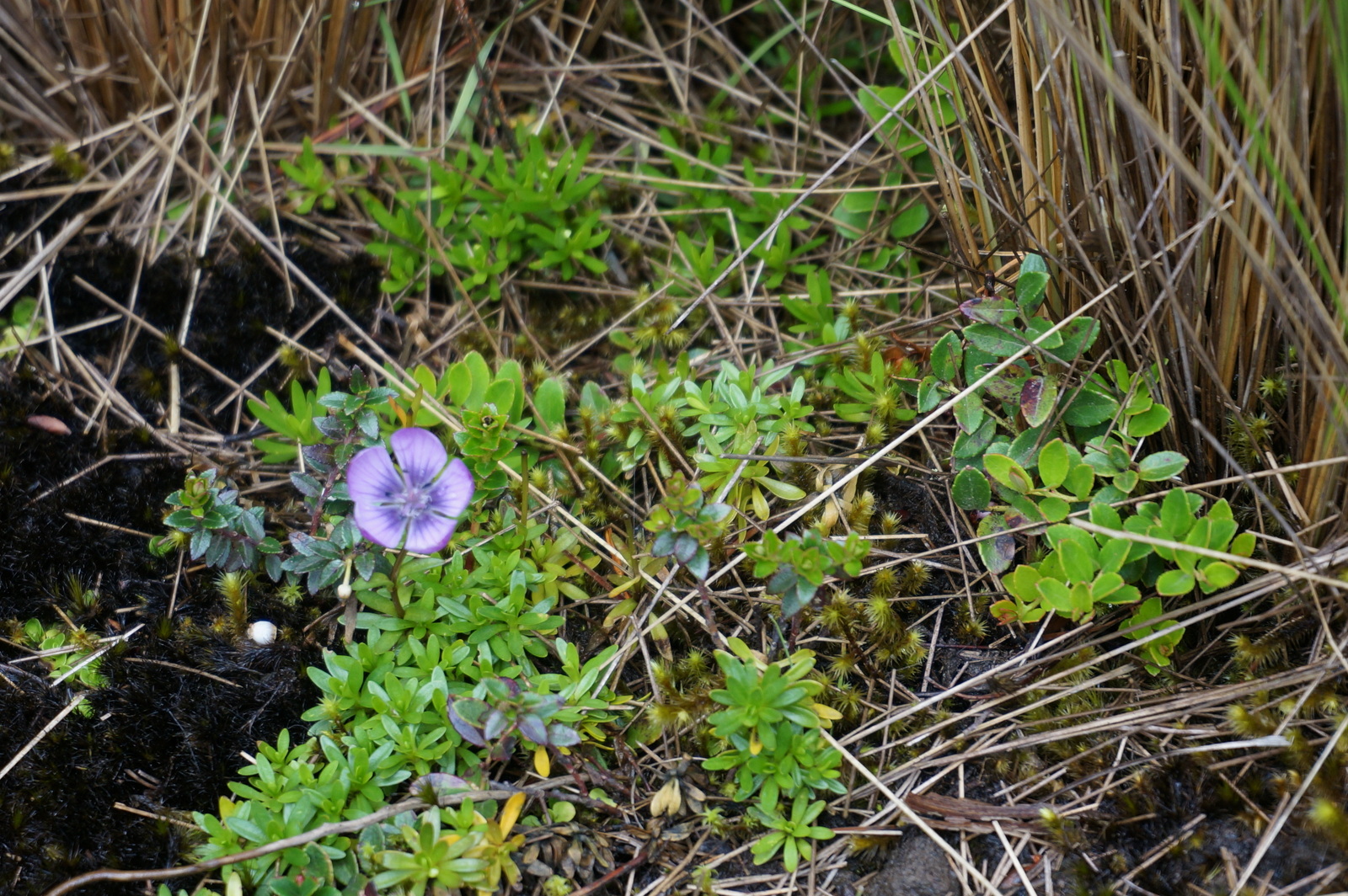


Bellavista is located on the Equator, which means flowers are in bloom all year long.

The area has 219 species of reptiles, 130 species of amphibians, and 270 species of mammals.

Some of the mammals at Bellavista include mountain lions; the endangered Spectacled Bear which is South America's only bear (they have yellowish-white rings around their eyes); the Andean Coati (a long, pointy-nosed raccoon); Kinkajoo (also called “honey bear”); Tayra (giant weasel); and the Olinguito (from the raccoon family). The Olinguito is a brand new species, discovered in 2013. The name means fog or mist, after the rainforest area in which it lives.


Image result for bellavista cloud forest Olinguito
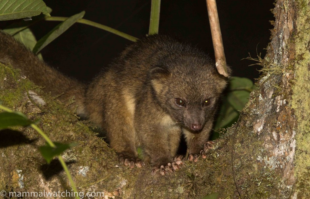
imagecredit:https://www.mammalwatching.com/2015/09/11/new-trip-report-bellavista-ecuador/

The Olinguito is a night creature, so every evening the lodge put out a bunch of bananas in the hopes of attracting it, but we never saw him.  Instead, every morning we saw the Tayra Weasel coming to steal the bananas that the Olinguito had snubbed.


We even saw squirrels making off with bananas bigger than they were!


On the first day, the morning hike was nice.  Our guide Juan Carlos had eagle eyes and could spot every single interesting plant, flower, or animal around.


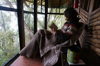
In the afternoon, it poured rain.  Juan Carlos suggested skipping the afternoon hike, so this is what we did instead (yes, it was chilly):


Instead, he took us on a night hike after dinner, in the dark.  The rain had stopped and this turned out to be one of our favourite hikes.  We saw tons of critters that you don't find during the day:


The rest of our stay turned out very nice, we were lucky indeed to not get any more rain, and we went on lots more interesting hikes, lasting about 3 hours each.  The trails wound up and down the mountain, we sure got some good exercise!


Bellavista gave us a free transfer back to the JW Marriott, where Celebrity is giving us a free transfer back to the airport later tonight for our 1 am flight, ugh.  We have to fly Quito to Miami at 1 am, then Miami to Toronto at 5:30 am.  We will be walking zombies by the time we land.  

In the meantime, since we have several hours to kill, the Marriott has been kind enough to give us free access to their gym and spa, so we are going to take advantage of that.  

This will be the last blog until our next travels, we hope you have enjoyed Ecuador!


Wednesday, February 13, 2019

Otavalo Market


Wednesday, February 13, 2019

Today we booked another private tour, taking a day trip to the famous Otavalo Market. Actually, we accidentally booked this tour twice, once with the wrong date.  Oops!

Our new guide Eduardo picked us up at Hotel Quito.  This was about a 2 hour drive east of Quito, along the Pan American Highway. Because it was just us and our driver, we got to stop at a number of lesser known attractions.

The first was Pisque River's viewpoint of Volcan Cayambe.  It was not a great viewpoint. The volcano was in clouds, and there were wires blocking the view.  If you bent low to avoid the wires, you were met with garbage on the ground.


Next we stopped at Miralago Hosteria to view San Pablo Lake:


Otavalo Market, Otavalo. One of the meanings of Otavalo is "Blanket for Old People".  The town has 40,000 indigenous people, and most of them were here selling stuff.  The colours were wonderful:


Frankie was a bit chilly so she found this lovely sweater, 75% alpaca, 25% wool.


Just outside of Otavalo is the small peaceful village of Peguche Wasi. They are famous for their weavers and tapestries:


We had an interesting demonstration on how they make the different coloured dyes:


We had lunch in a town called Cotacachi (Salt Lagoon).  Afterwards we walked to look at their shops, every single one sold leather products.  Anton had a belt especially fitted for him:


Then an ecological reserve called Laguna Cuicocha, to see Cuicocha Crater Lake.  We were supposed to give our passport number to enter, but if we didn't have it, our guide told us just to write any old number like a mobile number, it was all bureaucracy.  Laguna Cuicocha means Guinea Pig Laguna, named because the largest island is a guinea pig shape.  Guinea pigs are highly prized as a source of protein:  they need minimum care and reproduce quickly.  


We walked along a very nice trail:


We had a nice shot of Imbabura here, another volcano:


This is a picture of Frankie telling Anton to stop pointing the camera at the backseat:


The drive there and back was quite interesting.  There are stray dogs everywhere:


We got stopped by police checks 3 times:


They had construction everywhere, even where the road looked perfect.  Merging into one lane was rather interesting:


Here's a delivery truck:


There is a whole town that specializes just in rose production:


When we got back to the apartment, we discovered that the internet was STILL out, that makes about 24 hours.  So we had a quick dinner and thought it would be a quick 1½ km walk to the Marriott hotel.  Well, it would have been if we had taken that left we were supposed to!  It was an interesting adventure walking the streets of Quito on our own, we have been very pandered to so far.  It was made more interesting by the fact that every shop had its own sidewalk, sometimes differing in elevation:


We decided to take a taxi back to the apartment!

Tuesday, February 12, 2019

Cotopaxi National Park


Tuesday, February 12, 2019

The nice thing about this apartment is that it backs onto a pedestrian walkway, so there is very little traffic noise.  The pedestrian walkway, however, is quite well lit at night.  The blinds in the bedroom did absolutely nothing to keep the light out.  Thank goodness we packed sleep masks!

Today we took a private tour (just us) to Cotopaxi National Park. We met our driver Christian at the Hotel Quito at 8 am, which was an 8 minute walk away.  We figured that would be easier than him trying to find the apartment.

On the way, we stopped at an overlook of Quito.  Quito is 20 kms wide and 60 km north to south.


Cotopaxi National Park is 60 km south of Quito and took us about 2 hours to get there. You can see Cotopaxi quite clearly from Quito on a clear day:


Image result for cotopaxi eruption ash in quito
imagecredit:https://cairesonmission.com/2015/09/16/are-you-ready/

It was declared a national park in 1975, and has almost 80,000 acres. It is best known for the Cotopaxi Volcano, which is Ecuador's 2nd highest peak at 19,347 ft (5,897 m). It is the world's highest continuously active volcano. There have been 87 recorded eruptions. The nearby city of Latacunga (population 100,000) has been completely destroyed twice.


Image result for cotopaxi eruption ash
imagecredit:https://www.foxnews.com/world/new-bursts-of-ash-and-gas-rise-from-ecuadors-cotopaxi-volcano

The worst eruption occurred in 1877. The volcano violently ejected hot ash, lava fragments, and gases that flowed at great speed, reaching Quito within 3 hours and covering the city in 6 mm of ash.

Image result for quito covered in ash from cotopaxi
imagecredit:https://cuencahighlife.com/explosions-and-earthquakes-rock-cotopaxi-volcano-ashfall-and-the-smell-of-sulfur-reported-in-southern-suburbs-of-quito/

The most recent eruption was in August, 2015. There were 2 eruptions followed by 2,100 minor earthquakes and 20,000 tonnes of sulfur dioxide emissions. Following this eruption, the national park was closed to visitors but has recently reopened. The park has reopened the trail to the Jose Ribas Refuge at 15,748 ft (4,800 m).


Image result for Jose Ribas Refuge
imagecredit:https://photoseek.photoshelter.com/image/I0000eO7aPAqxWf8

The Ecuadorian Ministry of Tourism assures visitors that they have everything firmly under control. From their website:

The Ecuadorian Government have improved the volcanic monitoring system. Evidence of this is the provision of technological equipment that reinforces the current monitoring network, which operates 365 days a year and supports the Early Warning System. Among them: 16 seismic stations, 5 infrasound detectors, 13 lahars detectors, 7 video telemetry stations, 1 thermal imaging camera, 12 deformation control lines, 5 inclinometers, 5 GPS stations, 5 gas monitoring stations, 1 multi-gas mobile, Ash meters and 10 repeaters.

Since the volcano is so high, there is actually a glacier at the top. Ecuadorians love to climb the volcano, and for many of them, it is their first exposure to snow.


The terrain of the national park is relatively flat with large volcanic boulders, until the volcano surges up out of it. This makes it easy to see the volcano no matter where you are. The land below the volcano is an ecological reserve. Wildlife includes wolves, pumas, bears, condors, wild horses, and foxes.

We were a little surprised when Christian said we were leaving his car at the visitor center, and taking a park vehicle, along with another guide and driver.  So now there were 5 of us.  Christian said the road in was too rough and he wanted to save his car.  They called the ride a "free massage".


The visit began with the Visitor Center and small museum.  The museum and surrounding hiking trails are at an elevation of 14,764 ft (4,500 m), almost as high as the refuge.  The museum just opened yesterday, so the guides were tickled pink to go through, and took a really long time explaining everything you wanted to know about the park (and everything you didn't want to know!).


From the museum, we hiked 1½ km on a trail through what they called a "botanical garden".  We only saw a few flowers, it just looked like a nice trail to us.  We wondered why they kept stopping at every little plant and flower to show us.  Then the altitude started to get to us and we were huffing and puffing, so taking pictures of every little plant and flower became a great excuse to rest.


We followed along a ravine:


It took us twice as long to hike this trail as it would have back home.  It kept seeming to go up and up.


There are several small lakes in the park, and one larger lake, Laguna Limpiopungo. This is a seasonal lake which grows larger in size during the rainy season.


We took a 2½ km hike around the lake, going very slowly!  Our new guide Marina had an eagle eye for finding every little plant or animal.  We could not believe there are lizards living here, it was a chilly 10C up here.


And breezy, as you can tell by these pictures:


There were several times when we were able to see Cotapaxi without clouds.  The vertical cloud wall was very interesting.


This area is where wild horses and llamas are often seen grazing.


By the time we were done this second hike, they asked if we wanted to go hike a different area.  But it was 1:30 and we were very hungry, so we all headed back.  We said goodbye to the extra driver, and Marina:


Christian wouldn't let us eat at the visitor center restaurant, he said they wouldn't be able to accommodate any "eating restrictions".  He promised to take us to a nice restaurant "only 20 minutes away".  Hmph.  He took us onto some back roads that led where?  To a guarded colonial mansion.


Anton asked how much lunch would cost here.  Only $25US each.  1)  We didn't bring that kind of money for lunch; and 2)  Can you say driver kickback????  So we said no and he said he could take us to another town for lunch, only half an hour away.  By this time it was close to 3pm, so we told him to take us back to our bnb.  Can you say "hangry"?

So we had a rather early supper (late lunch?) of kraft dinner and felt much better.