Wednesday,
February 6, 2019
Each day in the Galapagos gets more and more awesome!!!!
Each day in the Galapagos gets more and more awesome!!!!
Today
we were on Isabela Island. The island sits on the Equator. From
above, its shape is like a seahorse. It
is the largest island (4670 sq km). It is just over 120 km from north to south.
Isabela contains more than half the total landmass of all the
islands, and reaches 5600 feet (1700 m) in elevation. Compare this
with the elevation of Toronto: 249 feet.


imagecredit:https://www.vacationstogo.com/cruise_port/Isabela__Galapagos_Islands__Ecuador.cfm
Isabela
is one of the islands with inhabitants (population 1749). The people
here make their living from fishing, farming, and tourism.
Isabela
Island was formed by 6 volcanoes, 5 of which are still very active. There have been 11 eruptions in
the last 50 years. In 1998, rescuers had to move several rare giant tortoises out of the
lava flow. In
June 2018, the Sierra Negra volcano on Isabela Island erupted,
forcing a short evacuation of 50 residents. Sierra Negra has one of
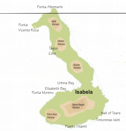
the largest craters in the world, with a diameter of almost 10 km. The following shows the volcanoes, and the equator:


imagecredit:https://www.ladatco.com/GPS%20Gate%202012%20MAP%20-%20Isabela.htm
Isabela
Island is home to more wild tortoises than all the other islands
combined. There are 5 subspecies of giant tortoise on the island,
one subspecies for each volcano. This is because lava is too
difficult for tortoises to cross.
This
past October, 123 baby giant tortoises were stolen from a breeding
facility on Isabela.
Marine
life around the island includes humpback whales, stingrays, sharks,
marine iguanas, and sea turtles. This is considered to be the best
place in the Galapagos to see whales; 16 species have been spotted
here.
In
the morning we were at Punta Moreno (7 am to 12 pm). This is the
farthest south that visitors can land on the western side of
Isabela. Not many people land here because it is difficult to maneuver
through the mangrove lagoons on the way to the landing point. We were told to wear long sleeves and pants and good hiking shoes.
The hike this morning was completely different from the other islands we have been on. We climbed out of the zodiac onto fields of lava.
The "trails" through the lava fields were marked by posts. This is Diego, one of the naturalists. Can you see the post?
The lava was the pahoehoe type: basaltic lava forming smooth undulating or ropy masses. The word pahoehoe comes from the Hawaiian word for “paddle”.
The "trails" through the lava fields were marked by posts. This is Diego, one of the naturalists. Can you see the post?
The lava was the pahoehoe type: basaltic lava forming smooth undulating or ropy masses. The word pahoehoe comes from the Hawaiian word for “paddle”.
There
was lava cactus.
There
were lagoons formed by lava flow. The water is a mix of both sea and
fresh water.
We had to be careful of the deep crevasses in the lava.
After our hike, we climbed back onto the zodiac.
The zodiac went around some rock islands. One of the islands was full of basking marine iguanas.
Everyone was very excited because we saw our first penguins and flightless cormorants.
Lunch is always back on the ship. They must be overwhelmed with doing all that cheap laundry today, because the sheets on our bed were damp. While the cabin attendant was changing them, another passenger came to find her because their sheets were wet too.
After lunch, we had a tour of the bridge. It was really interesting. The chief navigator let us sit in the captain's chair but we weren't supposed to tell.
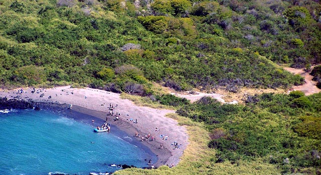
In the afternoon, we were at Urbina Bay, also known as Urvina Bay (2 pm to 7 pm). It is named after a former President José Maria Urvina of Ecuador in the mid 1800s. The confusion in the name comes because the president's son started to sign his name as Urbina.

imagecredit:https://www.bestofgalapagos.com/galapagos-islands-information/galapagos-islands-isabela-island-urbina-bay.htm
Urbina
Bay is situated at the bottom of Volcán
Alcedo. The largest population of Galapagos tortoises live here,
about 5000 of them. They were almost wiped out by the release of
goats in the area in 1968, as the population of the goats reached
100,000 by 1995. The feral goat and donkey populations were
eliminated between 1997 and 2006 with Project Isabela. Their
elimination also helped the local vegetation to rebound. There is
still a problem on the island with cats and rats that is affecting
the bird life and small reptiles.
For our excursion
option we chose the "long fast-paced walk" and they weren't kidding. We didn't expect to be wading through lagoons with our walking shoes, or climbing over lava rocks.
The
coast line here was extended about a km in 1954 when volcanic
activity caused the ocean floor to uplift. A 6 km stretch of coral
reef was raised up 5 m. Thus our path meant we were walking on
former coral reef. The coral reef is deteriorating due to exposure
to the air. Scientists have drilled and found the age of this coral piece to be 400 years old.
The
volcanic material here is pumice. The same kind you would use to
buff your dead skin with.


imagecredit:https://homequicks.com/pumice-uses
Once we got away from the coastline the walking got a bit easier, although you had to be careful not to walk on iguana or tortoise scat.
We were so excited to see our first land iguanas:
And our first giant tortoises!!!! These ones roam free in the wild:
The walk was hot, hot, hot!!! So sorry for the folks with the ice storm back home.
When we got back to the beach, we had about an hour for snorkeling. The current was pretty strong here and we kept being pushed into the rocks.
And then!!! A pair of giant sea turtles!!! They swam with us and didn't seem to care about us at all!
After snorkeling, the zodiac zips us back, and once on board we have to follow quite the process. First, rinse your shoes. Then hand in your life jacket. Take off the wetsuit and dip in pail # 1. Rinse in pail # 2. Dip your snorkel gear in pail # 3. Hang up your wetsuits and hand them in. Hand in your snorkel bags (all labelled with our room number). Rinse shoes again. This is all to protect against cross-contamination of the islands.


This is amazing! Thank you for sharing these interesting photos and fascinating information. So wonderful to see you enjoying this trip!
ReplyDelete